

 SKYTRAC Systems Ltd. (SKYTRAC), a leading satellite communication (Satcom) and intelligent connectivity solutions provider, and TerraSense Analytics, a developer of artificial intelligence (AI) and sensor fusion technologies, have announced a strategic partnership to bring their combined capabilities to Transport Canada’s National Aerial Surveillance Program (NASP) for Maritime and Arctic Intelligence, Surveillance, and Reconnaissance (ISR).
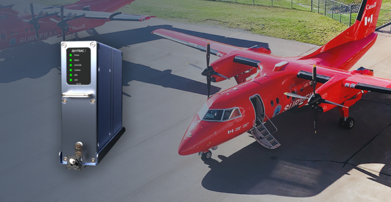
The SKYTRAC SDL-350 Satcom terminal will provide Transport Canada’s Dash-7 and Dash-8 aircraft with Iridium Certus connectivity, enabling up to 704 Kbps of bandwidth. The connectivity will provide the aircraft with the capability to transmit live video, EO/IR imaging, and much more, directly to the ground in real-time.
“We have partners in multiple segments of aviation which rely on onboard cameras and sensors for intelligence, surveillance, and reconnaissance applications. While studying their various use-cases, it became clear to us that artificial intelligence combined with live video could enhance their operation,” explained Jan van der Heul, Vice President of Sales of SKYTRAC. “We see AI as a core technology heading into the future, and we’re excited to roll out these new capabilities in partnership with TerraSense.”
The TerraSense MIST technology, which will be hosted on board SKYTRAC’s SDL-350, will seamlessly fuse, process, and analyze camera and sensor data with minimal latency. The unique system will process electro-optical (EO), infrared (IR), ultraviolet (UV), and side looking airborne radar (SLAR) in real-time, providing the operator with live tracking and alerting. MIST also enables analysts to rapidly search and retrieve video and metadata from multiple aerial platforms for post mission analysis.
The SDL-350 and MIST system for target detection and tracking is capable of autonomously identifying a diverse range of intelligence requirements including fishing and cargo vessels, naval traffic, threats to border security, and search and rescue. The MIST platform mitigates human factors such as fatigue, training, distraction and bias, as well as increases the persistence of surveillance without compromising the health of aircrews.
“We set out to create a truly usable artificial intelligence system, one that can withstand the rigors of real-life operations and the demands of highly-trained operators without the learning curves found in legacy systems,” mentioned Jozsef Hamari, TerraSense’s Chief Technology Officer.
Though broadband satellite communication services have existed prior to Iridium Certus, none have been capable of truly global operations. The Iridium Certus satellite service, which operates on a Low Earth Orbit (LEO) constellation, offers a much lower size, weight, and power (SWaP), at a lower cost point than legacy solutions.
The new solution will ultimately be marketed to the Military and Government, Search and Rescue (SAR), Coast Guard, Law Enforcement, and Unmanned segments of aviation.
For more information on the SDL-350 and TerraSense collaboration, please visit go.skytrac.ca/certus or contact a technical sales expert at sales@skytrac.ca.

About SKYTRAC Systems Ltd.
SKYTRAC is aviation’s full-service, data-driven solutions provider serving the fixed-wing, rotorcraft, and unmanned aviation markets. Since 1986, SKYTRAC has pioneered the development, evolution and commercialization of flight following, flight data and communications technology. Today, with systems certified on over 900 airframes and an online data management portal that is the go-to tool for over 7,500 global users, SKYTRAC is truly the partner of choice for data-guided business insights. From performance trending and operations reporting to real-time asset tracking and situational awareness – SKYTRAC offers a one- stop response to meeting more of your company’s needs.
About TerraSense Analytics
TerraSense Analytics develops remote sensing technologies with a focus on deep learning. Partnered with several research institutions to advance the development of aerial sensing technology, data fusion and predictive maintenance, TerraSense Analytics provides services to both the government and the private sector, deploying intelligent sensor solutions to the most remote and hostile domains.