


The weather systems above the Java Sea at the time Jakarta control lost contact with Indonesia AirAsia flight QZ8501 look like angry red boils on the surface of the earth — perhaps one reason the image went viral on Twitter quickly after the incident and was soon picked up by the general media.
Together with Indonesian Transport Ministry official Hadi Mustofa’s description of the pilot’s request to climb and vector around clouds as “unusual”, QZ8501’s narrative began with a preconception that the weather was at fault in the incident.
It is clearly far too early to analyze whether weather was a significant contributing factor to the incident — but analysis of the meteorological conditions on the morning of 28 December can give some context to the flight and its preparations.
Runway Girl Network spoke with Simon Proud, an aviation safety researcher at the University of Copenhagen who specializes in satellite data. Proud analyzed the meteorological conditions over the Java Sea on the morning of 28 December, which weren’t particularly unusual.
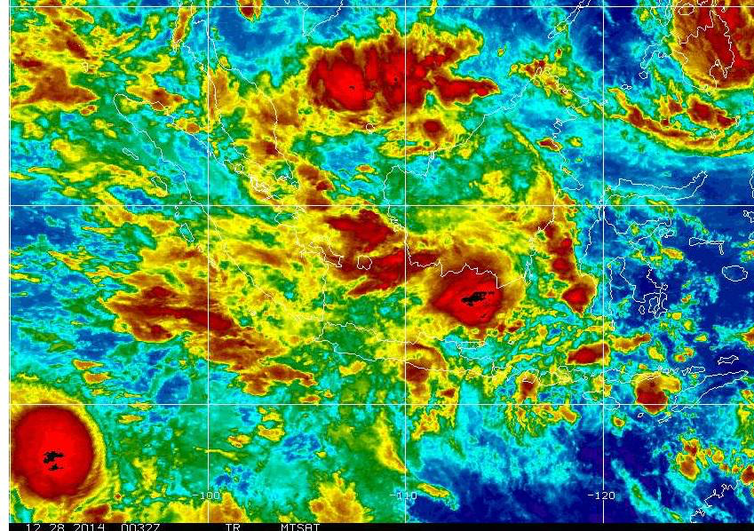
Credit: US NOAA
Proud, who came to RGN’s attention during his analysis of the AH5017 crash in Mali earlier this year, started by explaining what the widely circulated weather image actually shows: “a satellite view of the region. It is an infrared image in which the varying colour denotes an estimate of the temperature of the tops of the clouds. The black colour will be coolest, then red, yellow, green, etc. The blue colours are warmest, probably around +10C. Black is probably around -70/80C although I can’t be sure unless I know the exact time/satellite.”
“It tells us where the most severe weather is. Convective storms result in clouds reaching very high altitude — and the higher the cloud the colder it will be. Clouds at -70C will probably be around 50,000ft in this region. In general the severity of a storm is directly proportional to the altitude that the clouds reach,” Proud explained.
This kind of weather is not especially unusual for the region, dominated at this time of year by the Inter-Tropical Convergence Zone, or ITCZ.
“The ITCZ is an area similar to a weather front, characterised by frequent and often severe thunderstorms. It stretches around the globe and moves North or South depending on the season. At this time of year it is slightly to the South of the equator,” Proud said.
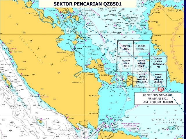
QZ8501’s flight path took it from seven degrees south at Surabaya, to approximately three degrees south between waypoints TAVIP and RAFIS on airway M635.
“The main effect of the ITCZ is the prevalence of thunderstorms. These can cause turbulence as well as lightning strikes and other more serious events (such as the loss of Air France 447 and Swiftair-operated Air Algerie flight 5017 due to icing),” Proud continued. “It also means that flights have to carry extra fuel to prepare for possible diversions around the most severe of the weather.”
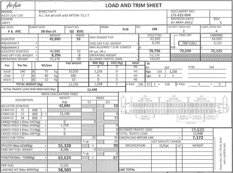
QZ8501 did indeed carry extra fuel: 8,296kg, 62% extra in addition to the trip fuel calculation of 5,121kg, according to the load and trim sheet released by the Indonesian government.
In their preparations, Proud assessed that the crew would have had access to a certain amount of standard weather information.
“The weather information available to the crew depends very much on the airline. It may range from a ‘significant weather’ chart (which can often be vague or inaccurate) and some data on conditions at the departure and arrival airports up to something much more complex. In most cases the crew will have access to some satellite data showing cloud formations, but this would only be pre-departure and could be several hours old. In-flight they will have their weather radar and also information transmitted over radio from other aircraft and air traffic control in the region, which would give turbulence reports and so on.”
But, Proud emphasised, “the weather situation looks challenging, but nothing out of the ordinary. That area is well known for having severe weather and a crew with as much experience as this one would probably have faced worse weather in the past.”
Indeed, pilot in command Iryanto was a seriously experienced airman, with 20,537 flying hours, of which 6,100 were in type and with Indonesia AirAsia. First officer Remi Plesel had 2,275 flying hours with the company — again, more than adequate for the aircraft.
Perhaps some kind of extreme weather phenomenon developed in the forty-two minutes between takeoff and the loss of contact with QZ8501?
“I don’t have access to much data for that region, but it appears not,” Proud said. “There were storms but they’d been there for some time.”
They seemed to have been well forecast — and, again, not out of the ordinary. Compare the similar ’significant weather’ charts for 28 December, the day of the incident:

and the chart for 29 December:
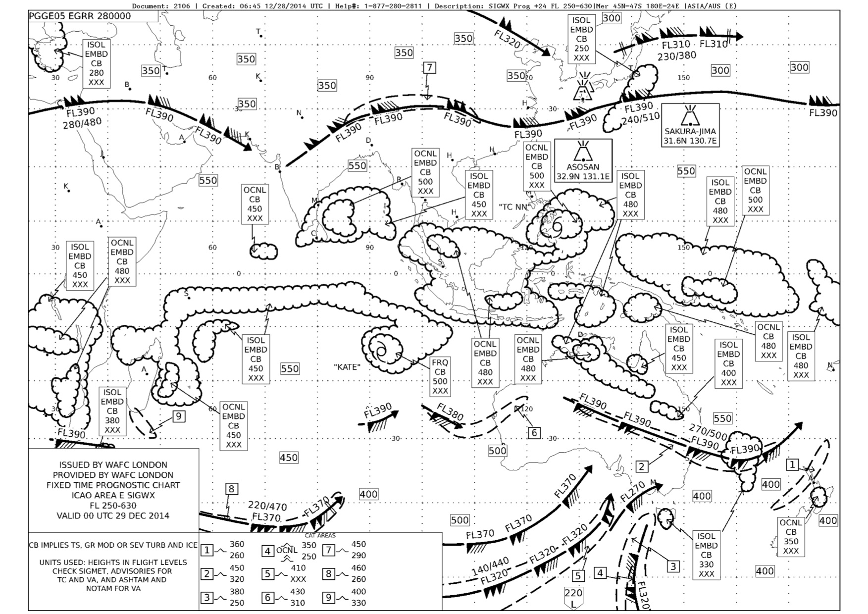
Both days have a similar thunderstorm forecast, either isolated (covering less than 50 percent of the area illustrated) or occasional (covering 50-75 percent of the area), and both forecast embedded storms — within cloud layers that might not be readily recognised.
So: QZ8501 had highly experienced flight crew, with significant time in type, flying between familiar airports, extensively familiar with the region, and experiencing forecast weather that appeared typical for the location and time of year — and in a six-year-old aircraft operating for an airline group with only one previous safety incident, a hard landing in 2007.
What went wrong?